Laurel County - U.S. 25 North Leg

Congestion relief for today and tomorrow 


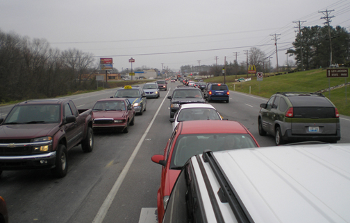
Explosive growth along the U.S. 25 corridor south of its junction with KY 192 has resulted in near daily gridlock as motorists converge on the myriad businesses as well as neighboring South Laurel High/Middle School and the London-Corbin Airport.

This $16 million project will endeavor to relieve the congestion and improve the route's viability for years to come through the implementation of several strategies. Some portions will be widened, some of the existing traffic will be diverted onto alternative routes and access control measures will consolidate entrances and exits to improve ingress and egress to businesses.

Improvements are planned to encompass the entirety of U.S. 25 between London and North Corbin. This project, known as the North Leg, includes the points between KY 229 and KY 1006; the South Leg section, which does not have construction funding at present, would include points between KY 1006 and U.S. 25E.

Views of the Job


Trial License has expired!
Evaluation Version (© 2011 AMREIN ENGINEERING AG)

The following link will open a Google Earth view of the U.S. 25 North Leg project corridor. This allows you to see the paths and characteristics of the design relative to your neighborhood.​

Google Earth project views

​4 Lane Rev


Documents produced throughout the life of the project are available here.

Project Scope/Statistics/Early Alternate Designs

Scoping Study
 
 
Crash History
 
Traffic Volumes
 
Alternates
 
Current Designs and Related Resources
 
Conceptual Design
 
Traffic Circulation Routes
 
Project Impacts - U.S. 25
 
Project Impacts - KY 229
 
U.S. 25 Roll Plot 1
 
U.S. 25 Roll Plot 2
 
KY 229 Roll Plot
 
Public Meeting Materials
 
April 2013 Public Meeting Handout 1
 
April 2013 Public Meeting Handout 2


​This page is maintained by Les.Dixon@ky.gov, who may be contacted to make corrections or changes.

Follow Us