WHAT IS ARCHAEOLOGY? Archaeology is the scientific study of prehistoric and historic peoples through the objects they have left behind. Artifacts and archaeological sites (and archaeologists) can be found anywhere that people have lived, even if they only lived there for very short periods of time. Archaeologists try to recreate and understand past human behavior through the study of the artifacts and features left by previous occupants. Artifacts are objects greater than fifty years of age and made by humans, and features are places where people have disturbed the earth. Artifacts include fragments of old plates or bottles, or projectile points and prehistoric pottery. Many artifacts were made only for short periods of time and can help an archaeologist learn when a site was occupied. Features may include an old well or building foundation, or an old hearth or a pit dug to hold trash. Features provide clues as to how long people lived at a site, or what kind of activities took place there. By examining the relationship of artifacts and features within and between sites, archaeologists try to recreate information that may not be found in written records.
People often identify the science of archaeology with Greek temples or Egyptian pyramids and may be surprised to learn that Kentucky has more than 25,000 recorded archaeological sites and probably far more sites that are unrecorded. Archaeological sites can be any location where people have lived or left evidence of their passing that is at least fifty years old. American Indians have lived in Kentucky since at least 12,000 years ago, near the end of the Pleistocene. Many of the places American Indians lived in Kentucky were large village sites, several of which were still inhabited when European explorers arrived in Kentucky in the 17th century. By the 18th century, Euro-American settlement began in earnest and thousands of farmstead, industrial, and military sites now dot Kentucky’s landscape. Africans and African-Americans, both enslaved and free, came to Kentucky during the 18th and 19th centuries, adding their stories to the archaeological record. There are dozens of archaeologists currently employed in Kentucky by universities, private consulting firms, and government agencies, trying to uncover, record, analyze, and preserve these stories. Archaeologists do not study dinosaurs (that’s paleontology) and rarely find themselves in snake-infested ancient temples (unless they’re in a
movie).
KYTC ARCHAEOLOGISTS
The Kentucky Transportation Cabinet (KYTC) is committed to protecting and preserving Kentucky’s past. This goal is aided in part by the dedication of KYTC’s archaeological staff in the Division of Environmental Analysis. KYTC’s archaeological staff reviews nearly every highway project to determine if the project could impact archaeological resources. KYTC’s archaeologists are also responsible for maintaining the Cabinet’s compliance with various state and federal laws on historic preservation. Because of the breadth of KYTC projects across the state, the Cabinet is typically responsible for conducting a greater number of archaeological investigations than any other agency in Kentucky.
The Division of Environmental Analysis can be found at the Transportation Cabinet Building located at 200 Mero Street, in Frankfort, Kentucky. KYTC-DEA employs three archaeologists to oversee all aspects of transportation-related archaeological investigations in the state. Each archaeologist is responsible for four of the state’s
12 highway districts and their responsibilities include archaeological project management, review, agency coordination, and fieldwork.
Susan Neumeyer: Districts 2, 4, 5, and 10
Carl Shields: Districts 7, 8, 9, and 11
Consultants to the Cabinet complete most transportation-related archaeological investigations. KYTC archaeological staff may develop scopes of work specific to each project, monitor the work of the Cabinet’s consultants, and review submitted archaeological reports to ensure that high quality work is being performed.
HOW THE PROCESS WORKSFor projects with federal funding or permits, an environmental study is required to assess the potential for the project to impact or destroy archaeological resources. The starting point for federal projects is often an overview to determine what sites may already have been identified in a project area, followed by a Phase I survey to look for any unidentified archaeological sites. For projects with state funding, an assessment of the project to impact archaeological sites is made to determine if a survey will be required.
Overview - Assessment of potential: The first step in assessing the potential of a project to impact archaeological sites is determining if any sites have previously been identified in the project area, or if the area has been previously surveyed. Once this determination has been made, archaeologists must consider whether the project has new right-of-way and if recent construction or other activities have disturbed the area. Historic maps and documents may be utilized to try and find any potential historic archaeological sites in a project area. Using previous surveys and recorded site location information, archaeologists must try to understand the probability that a given area may contain archaeological sites. Based on an assessment of the potential of an area to contain archaeological sites, recommendations for further work can be made.
 Phase I - Survey and Site Discovery:
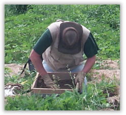
 Archaeological survey is the examination of a project area to try and locate any archaeological sites that may be within the project’s footprint. Survey is completed by walking over areas with good visibility, such as plowed fields, or digging shovel probes at regular intervals in areas of poor visibility, such as overgrown fields. All dirt from the probes will be pushed through a screen to recover any artifacts that may be present. If a site contains few artifacts, cannot be dated on the basis of the recovered artifacts, or has been disturbed so that all of the soils containing artifacts have been mixed, no additional work will be required. If there are numerous artifacts, the age of the site can be determined through the recovered artifacts, or archaeologists find evidence of buried features, a Phase II evaluation may be required.
Phase II - Site Evaluation: Phase II excavations are done to
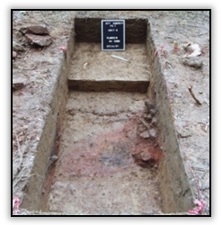
find out if a site is eligible for nomination to the National Register of Historic Places (NRHP). Evaluations may include hand-excavated test units, large-scale excavation using mechanical equipment, the use of specialized scientific equipment such as ground-penetrating radar, and extensive research of archival documents. At the Phase II evaluation, archaeologists are trying to find out how much of the site has not been disturbed and how much we can learn from the site. If there are large numbers of artifacts and features, or if the site has not been disturbed by construction or erosion, the site may contain unique information that may tell us a great deal about the people that lived there. Sites that contain unique information may be considered significant, which makes them eligible for nomination to the NRHP. If a site is eligible, the impact can be offset by expanding our investigation to learn as much as possible from the site prior to its destruction.
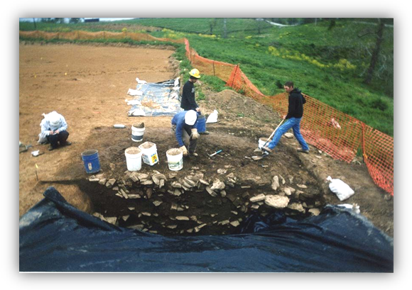
Phase III - Mitigation of Adverse Affect: If a site is eligible for nomination to the NRHP, it should be avoided by redesign of the project, if possible. If it is not possible to avoid the site, data recovery excavations must take place to mitigate the adverse affect to the site. Excavation strategies must include a detailed strategy that tells what we want to learn from the site and how to best accomplish the goal of recovery. Data recovery plans must be approved by the SHPO and the Advisory Council for Historic Preservation (ACHP) must be given the opportunity to comment on the plan. Site mitigation plans must also include an educational component, that may consist of booklets, pamphlets, brochures, videos, or K-12 lesson plans developed for use with
Project Archaeology.
KRS 164.705 to .735 (State Antiquities Act)Declares the public policy of the Commonwealth to be preservation of archaeological sites and objects of antiquity for the public benefit and of limiting exploration and collection of such matters to qualified persons and educational institutions.
Outlines the permitting process required to remove or excavate archaeological sites or objects of antiquity from state land, and makes removal or excavation by non-permitted individuals a felony.
Section 4(f) (Department of Transportation Act)
Prohibits federally funded projects from impacting significant archaeological sites that may warrant preservation in place without consideration of prudent or feasible alternatives and planning to ensure minimization of harm to the property.
Additional Federal regulations concerning archaeology
