Data Recovery Excavations at Site 15Bh212, Bath County, Kentucky
Based on a summary by Stevan C. Pullins
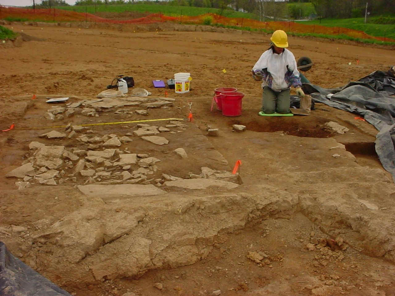
Site 15BH212 is a small farmstead located in the westernmost corner of Bath County just south of Sharpsburg. The site is situated within the physiographic region known as “The Knobs”, just east of the Inner Bluegrass Region in eastern Kentucky. Phase III data recovery excavations were conducted by Cultural Resource Analysts, Inc. from March 24 to May 8, 2003.
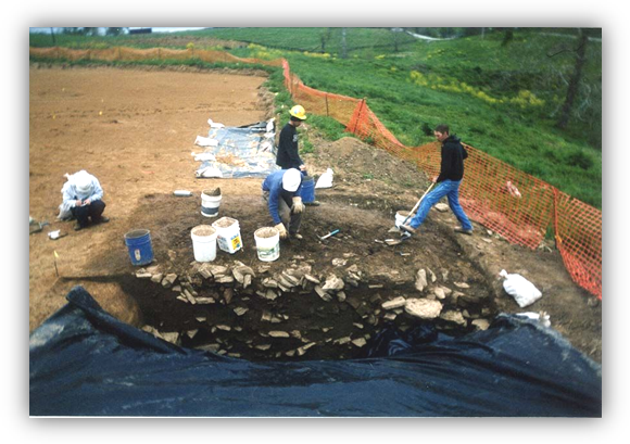
The field phase began with the re-identification of the proposed limits of right-of-way (ROW) and the establishment of the area to be mechanically stripped. This portion of the fieldwork consisted of mechanical removal of the plowzone using a trackhoe equipped with a toothless bucket, with a dump truck used to transport the soil to an adjacent area within the project ROW. The stripping process was carefully monitored at all times, with shovel skimming conducted as necessary to aid in the identification and delineation of subsurface features such as cellars and hearths.
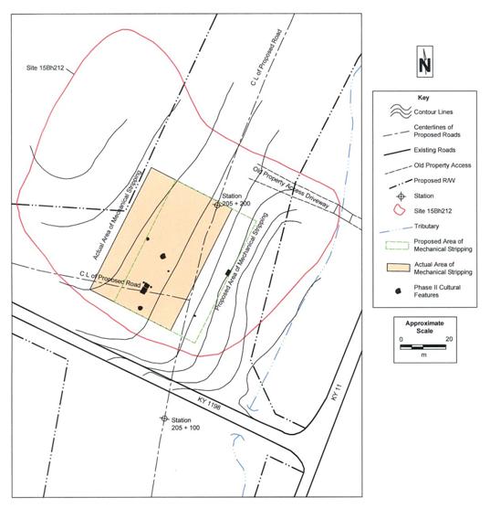
The proposed area to be stripped was a 40 x 60 m block oriented with a relatively level “bench” on the side of the knob above the creek that runs along the west side of Route 11. The size and positioning of the excavation block was designed to encompass features identified during the Phase II archaeological evaluation (Peres 2002). However, when this area was delineated at the site, it was found that the east edge of the proposed block would be on the more steeply sloped portion of the landform, about 12 m down from the top edge of the relatively level bench, and that block stripping and removal of this side slope would not be possible with the available machinery. Furthermore, there were serious doubts in the field that Feature 10, a root cellar discovered during the Phase II archaeological evaluation and projected to be located at the eastern edge of the excavation block, was actually located on the side of this steep slope, as indicated by projections made from the Phase II plan map. The decision was made to move the entire block location about 12 m west, bringing the western edge of the block to 2.20 m east of the west edge of the proposed ROW; this relocation placed the east edge of the block at the top edge of the slope above the creek.
The total area mechanically stripped during the data recovery was approximately 2400 square meters. Mechanical stripping was conducted to at least plowzone depth, with some stripped areas extending slightly deeper due to difficulties associated with stripping on a sloped surface. The stripped depth ranged from 0.24 to 0.47 m, depending on the thickness of the plowzone. The plowzone was thickest at the eastern edge of the site at the top of the slope, except where recent bulldozing of debris down the slope to the creek had thinned the plowzone profile. Generally, the stripping depth averaged about 0.35 m. Features identified during stripping and/or shovel skimming were logged, numbered, and flagged as they were discovered. Since 12 features had been previously discovered during the Phase II archaeological evaluation, feature numbering during the data recovery began with Feature 13.
After the plowzone had been stripped, a metric grid was established at a nail on the ground surface near the northwest corner of the excavation block, designated N1000 E1000.
Grid north was oriented with the landform to facilitate establishment of the grid; grid north is 36° east of magnetic north. A datum was established at a nail on the stripped surface at N942 E1008, near the southwestern corner of the excavation block. The elevation of the datum was determined with a Garmin GPSmap 76S using the datum NAD27 CONUS. The elevation at the site datum is 926 ft (282.24 m) amsl, and it is located at N38° 11' 44.5" / W083° 56' 21.9". The GPS accuracy at the time of the reading was 5.9 to 6.2 m.
Features
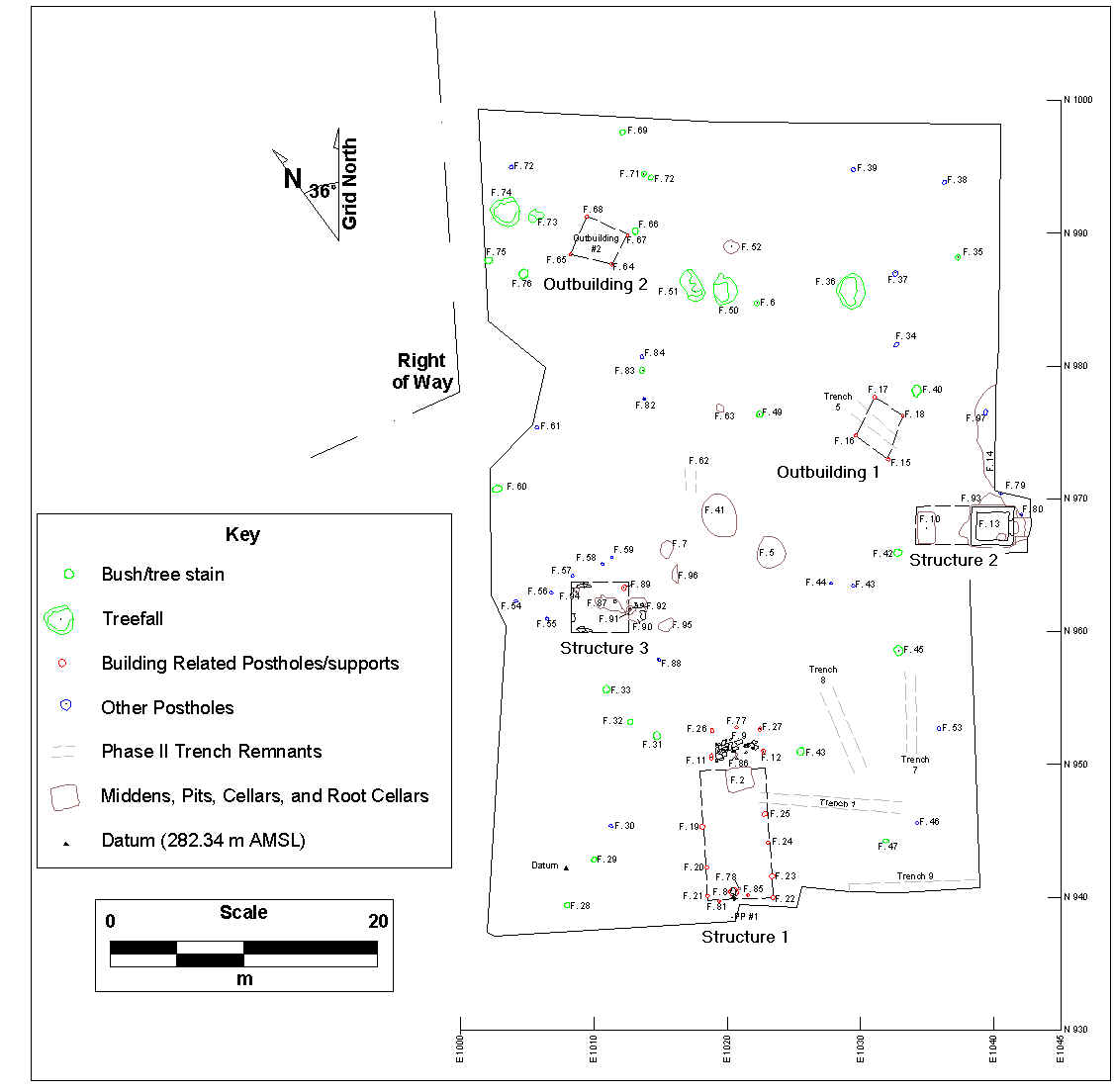
A total of 84 new features was identified during the Phase III data recovery, in addition to Features 1-12 that were originally identified during the Phase II archaeological evaluation. Numbered feature contexts include 57 cultural features, 25 tree or plant-related features, and two that represent portions of other features and do not represent a separate feature (classified as “not a feature”). These features combined to form a landscape built around three structures, including one with a stone-lined cellar. All three of these structures appear to have been systematically and purposefully abandoned and destroyed, perhaps to clear the landscape for farming. Approximately 514.5 liters of soil was retained from 42 of these features, and will be processed with a Flote-Tech flotation device to recover small floral remains.
Previously Identified Features
Nine of the 12 features originally identified during the Phase II archaeological evaluation were re-identified during the data recovery. These include two rock-filled pits (Features 5 and 7), three posthole or structural support features (Features 8, 11, and 12), a chimney foundation (Feature 9), one non-cultural feature (Feature 6), and both root cellars (Features 2 and 10). The limestone forming the chimney foundation had apparently been removed, piled to the side, and reburied. The limestone was uncovered by the trackhoe in a pile just north of the original location, which was re-identified based on the position of the associated Feature 2 root cellar and remnants of feature fill from the original location of the pad (Features 9 and 86). Most, but not all, of the limestone associated with Feature 8, a building support feature, had also been removed. A posthole-like feature was identified beneath one of the limestone pieces associated with Feature 8, and was excavated as Feature 8. Features 11 and 12, which form part of one of the structures identified, were re-excavated for the structure photograph. With the exception of Feature 10, which was partially re-excavated, the remaining features were mapped but not re-excavated.
Also identified were the remnants of Trenches 1, 5, 7, 8, and 9, as well as Test Unit 1, excavated during the Phase II archaeological evaluation (Peres 2002). The re-identification of these features, in conjunction with the re-identification of most of the previously excavated features, will enable us to closely tie Phase II and Phase III results.
The re-identification of the previously excavated trenches also confirmed that Feature 10 had been incorrectly placed on the Phase II site map. In fact, it was identified near the top edge of the slope within the excavation block. The feature was partially re-excavated to confirm the dimensions presented in the Phase II archaeological evaluation, and was found to be lined with black plastic sheeting (as were all of the re-identified features except posthole Features 11 and 12). A reconnaissance of the slope identified some evidence of the trenches excavated during the evaluation, but evidence for Trench 12 (in which Feature 10 was supposed to have been identified) had been obliterated by the recent bulldozing described earlier. Based on the actual location of the Feature 10 root cellar, it was probably identified during the excavation of Trench 5, rather than Trench 12, and subsequently mapped incorrectly.
Features Identified During the Phase III Data Recovery
A total of 84 new features was identified, most of which represent cultural features. The cultural features included 12 structural postholes and other supports, eight postholes that may represent two outbuildings, 25 fencepost postholes (eight of which include postmolds), a chimney, a hearth, an ash pit, a stone-lined cellar, a pit related to the destruction of the cellar building, a possible roasting pit, a root cellar, four small pits, and a sheet midden.
These features describe a landscape comprised of three structures and two outbuildings surrounding a central activity area, and a midden on the slope associated with Structure 2. Several fence lines and the non-cultural features will contribute to discussions of spatial organization and function; for example, a number of treefalls identified along the northern edge likely served to screen and separate this portion of the farmstead from the old access road just north of the site, used to cross the creek east of the site.
Structure 1
Structure 1 includes features originally identified during the Phase II archaeological evaluation. Feature 2 is the root cellar identified in front of what was probably the chimney/hearth (Feature 9). Although no hearth with burned earth or an ash pit was reported, a deposit of ash was reported within the adjacent Feature 2 root cellar as Feature 2a (Peres 2002). Features 11 and 12 were also re-identified and re-excavated to confirm their identity. Along with Features 26, 27, and 77, they probably combine to represent scaffolding for the construction of the chimney. No artifacts were reported for Features 11 and 12, although the profile shows brick within the post. Other than brick and limestone fragments, the only artifact recovered from scaffolding post Features 26, 27, and 77 is a small fragment of a pearlware vessel. The limestone and brick fragments were probably inserted into the posthole to stabilize the post during construction of the chimney.
Feature 2 was not re-excavated. The limestone slabs associated with Feature 9 had been removed during the previous excavation and placed to the side, where they were uncovered during the data recovery. Since they were displaced, they were removed from the excavation block. Feature 86, a shallow, irregular feature identified near Feature 9, likely represents an unexcavated remnant of the chimney footprint.
Features 19-25, 81, and 85 all represent structural posts or other supports for Structure 1. Features 19, 21, 81, 22, and 24 represent structural postholes that extend, on average, 18 cm below the stripped surface and range from 17 to 25 cm in diameter. Features 20, 85, 23, 25 represent shallow, more irregular features around the edge of the structure (in an alternating pattern with the postholes) that likely represent salvaged supplemental pier supports for the structure, perhaps made from locally available limestone (although no limestone was identified in any of these shallow features). The remnants of the pier support features average only 6 cm deep and range from 20 to 43 cm in diameter. Other than brick and limestone fragments, the only artifact recovered from these nine features is a piece of blue painted pearlware from the Feature 19 posthole.
The function of Feature 8, identified during the Phase II evaluation, is unclear. The Phase II report describes the feature as a “soil stain and limestone concentration” lacking “cohesion.” Some of the limestone pieces were re-identified, including a large piece with a clear soil stain extending from beneath the stone. During the Phase III data recovery, the feature was re-mapped and the stone was removed, revealing an amorphous, basin-shaped stain containing no additional limestone, brick, or other artifacts. It may be that Feature 8 represents a post feature that was removed and replaced with a limestone pier support, similar to what the remnants of Features 20, 85, 23, and 25 may have looked like. Piece Plot #1, a small grouping of 11 pieces of printed blue pearlware from the same vessel was identified about 1.4 m south of Feature 8.
The features associated with Structure 1 identify a residential building oriented parallel to the slope of the landform. Not including the exterior chimney, the building measures about 4.8 x 9.6 m (16 x 32 ft), with an off-center chimney and a single root cellar at the north end.
Structure 2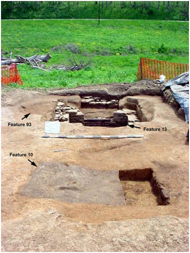
Structure 2 was identified about 16 m north and 12 m east of Structure 1, at the top edge of the slope and oriented perpendicular to the slope of the landform. Features identified in direct association with this structure include Feature 13, Feature 93, and Feature 80, as well as previously identified Feature 10; Feature 14 is indirectly associated. Feature 13 represents a stone-lined cellar that opens out eastward onto the downslope side of the building, and Feature 10 represents a root cellar about 2.2 m west of the cellar wall. Feature 93 is a basin-shaped pit opening into the north side of the cellar through a destroyed section of the cellar wall. Feature 80 represents a possible posthole that may or may not be associated with Structure 2. Feature 14 is a sheet midden identified just northeast of the Feature 13 cellar. There is little clear evidence for postholes or other structural supports that would aid in determining the size of the building; based on the identified features, the structure measures at least 3.66 x 7.31 m (12 x 24 ft).
Feature 13 is a stone-lined cellar located at the top edge of the slope, with an entrance on the downslope side. Limestone and brick rubble was identified by the trackhoe immediately below the surface; the machine was used to initially clear the area around the rubble concentration before continuing to strip the remainder of the site excavation block. The topsoil covering the rubble concentration was removed and screened; this context was designated “Feature 13 Associated Topsoil”; soil removed by hand excavation of the adjacent topsoil and shovel skimming around the rubble concentration (where necessary to expose the edges of the feature) was not screened.
In addition to 2,479 artifacts, approximately 13,419 pounds of limestone, 2,035 pounds of brick, and 77 pounds of mortar were removed from the cellar. Brick was sorted into whole bricks, corners for which the thickness or thickness and width could be measured, and rubble. All whole brick and a 10 percent sample of the corners were returned to the lab for further analysis; the remaining brick was weighed and discarded. Limestone rubble was weighed and returned to the cellar following completion of excavations at the site. Intact limestone walls were not removed.
The cellar extends 1.08 m (3.54 ft) below the stripped surface at the east end, and 1.4 m (4.59 ft) at the west end; rubble was piled in the cellar as high as 1.7 m (5.58 ft) above the cellar floor in the center of the feature. The interior of the cellar walls measured, on average, about 2.14 x 2.53 m (7 x 8.3 ft). A typical intact portion of the wall measured about 0.74 m (2.43 ft) high and 0.35 m (1.15 ft) wide. A wooden frame piece was recovered resting on a limestone base at the entrance to the cellar along the east wall. This entrance measured 1.08 m (3.54 ft) wide, and the remnants of stone steps were identified exiting the cellar. There is also a rectangular depression in the southeast corner of the floor of the cellar that measures 0.50 m x 0.70 m (1.64 x 2.3 ft), but the fill was the same as the rest of the fill at the base of the cellar.
All of the fill encountered in the feature appears to be related to the abandonment and destruction of the cellar. There are two layers of rubble, separated by a layer of soil with charcoal inclusions. The lower layer contains primarily limestone, while the upper layer contains limestone, most of the bricks and brick fragments (98 percent by weight) and most of the mortar (97 percent by weight) recovered from the feature. No mortar was found attached to any of the brick materials.
Artifact density was almost exactly the same for both rubble layers, and includes nails, window glass, pieces of framing wood, metal, redware, stoneware, porcelain, refined earthenwares (including pearlware), container glass, pipes, pins/needles, utensils, bone handles, marbles, buttons, faunal materials, and other artifacts.
Feature 10 is a root cellar located 2.66 m (8.72) ft west of the cellar’s west wall. Based on its placement and orientation relative to the stone-lined cellar, it appears to belong to the same structure. This feature was excavated during the Phase II archaeological evaluation (Peres 2002).
Feature 14 represents a sheet midden encountered just to the northeast of the Feature 13 cellar. This feature begins about a meter west of the lip of the slope at the eastern edge of the excavation block, and continues down slope towards the creek. About 7.82 m of midden was exposed by the trackhoe along the edge of the excavation block. The midden deposit measures about 18 cm thick in the profile exposed along the edge of the excavation block, but about 13 cm of this was mechanically removed during the stripping process due to strong similarities between the topsoil and the feature fill in soil color and texture. Five 1x1 m segments of the remaining feature fill (about 5 cm thick) were excavated, recovering 49 historic artifacts and 4.08 kg of small limestone fragments. Except for a lack of brick in Feature 14, the historic artifact assemblage is similar to that found in the adjacent cellar (Feature 13), and includes mortar, nails, metal, window glass, coarse and refined earthenware, and container glass.
Structure 3
Structure 3 was identified about 7 m north and 4.5 m west of Structure 1. Like Structure 2 (about 22 m to the east), Structure 3 is oriented perpendicular to the slope of the landform and on the same directional axis (54° west of magnetic north) as Structure 2. Features identified in association with Structure 3 include a partial foundation, chimney remnants with a hearth and ash pit, a posthole, a possible pier support remnant, an informal root cellar, and two shallow midden areas behind the chimney that have been disturbed by tree growth. The chimney is comprised of an ash pit (Feature 92), a hearth (Feature 91), and the remnants of a C-shaped limestone chimney foundation (Feature 92) on the east end of the building. Based on the remnants of the limestone foundation, the interior space of the structure measures roughly 3.05 x 3.96 m (10 x 13 ft); the exterior measures 3.96 x 4.88 m (13 x 16 ft).
 The entire floor of the structure was covered with small fragments of limestone rubble, initially obscuring the presence of Feature 87, an informal root cellar located in front of the hearth. This rubble consisted of generally small, irregular pieces, rather than larger foundation slabs. A number of larger foundation stones were still in place at the west end of the structure, providing a basis for defining interior and exterior space. Four 2 x 2 m test units were established at the west end of the structure, overlying the partial foundation, to control removal of the destruction debris within this interior area.
About 11 cm of soil was removed from the interior of the structure in these four test units to expose the subsoil, recovering 262 artifacts (not including brick, limestone, and mortar); nearly half of these artifacts are nails (47 percent). The limestone foundation remnants that were in situ were left in place. No stacked foundation pieces were identified; what remained of the foundation was only one layer thick, and was completely salvaged in places. The excavation of the four test units also revealed Feature 87, an oblong, irregularly-shaped feature extending from the front of the hearth to the center of the structure. This rubble-filled feature likely represents an informal root cellar, and contained 99 artifacts (not including brick, limestone, and mortar). General artifact classes include nails, metal, redware, porcelain, refined earthenwares, a piece of container glass, and a button. The presence of rubble in the feature suggests that the feature fill is probably related to the abandonment and destruction of the building.
The chimney, hearth, and ash pit (Features 90-92) were centered on the eastern end of the structure. A heavily charred pile of ash (the ash pit) was identified within an area of bright orange, heat-altered soil (the hearth). The hearth was in turn surrounded by the remnants of a limestone-based chimney. Most of the chimney was displaced rubble within a shallow builder’s trench, but a few larger stones appeared to be in place. The foundation of the chimney was set in a C-shape directly on the subsoil.
Outbuildings
There are two groups of postholes that may represent outbuildings, both located along the northern treeline separating the farmstead from the access road. Features 15-18 (Outbuilding 1) represent four posts forming a squarish polygon about 7 m north of Structure 2. Features 64, 65, 67, and 68 (Outbuilding 2) form a similar grouping about 33 m north of Structure 2 along the same line-of-sight. Although the spacing of these posts is irregular within each outbuilding (2.5 to 3.5 m - 8.2 to 11.5 ft), each outbuilding has one side that measures 2.5 m, two sides that measure 3.2 m, and one side that measures 3.5 m. The postholes in Outbuilding 1 averaged 23 cm in diameter and 19 cm deep; no artifacts were recovered during screening, although flotation samples were retained from each and are currently being processed. The postholes in Outbuilding 2 averaged 19 cm in diameter and 19 cm deep. As in Outbuilding 1, no artifacts were recovered during the screening process. Of these eight posthole features, only Feature 67 was not excavated.
Other Features
Feature 41 is a large, oval feature discovered between previously identified Features 5 and 7 (both of which are limestone-filled rock deposits). Feature 41, however, was much larger, and contained very little limestone in relationship to its volume. The feature measured 3.08 m x 2.84 m in plan. The basin-shaped profile extended 0.68 m below the stripped surface.
Two soil strata were identified within the feature. Zone A is a non-ashy silty loam soil stratum identified in the center of the basin (but not extending to the walls). About 16 pounds of small limestone fragments were recovered scattered within this zone, along with faunal materials, a piece of container glass, and a bone handle fragment. Zone B covered the entire base of the feature, and consisted of an ashy, gray, silty loam. Other than 66 pounds of small limestone fragments in small groups within the soil stratum, Zone B contained very few artifacts, most of which was faunal material from a large (and young, considering the presence of unfused epiphyses) mammal. Even so, there is clearly more than one type of animal represented. In addition, a few small fragments of nails, redware, refined earthenwares, container glass, and a Native American hafted biface were also recovered.
For its volume, the artifact density was extremely low in Feature 41. The limestone fragments were concentrated in the ashy layer, and differed greatly in size from the larger slabs and fragments in Features 5 and 7. The presence of an ashy layer, groups of small limestone fragments, and the presence of faunal materials all suggest that this was a large roasting pit; there was no suggestion that this was an intentional burial of a dead animal (the faunal materials were found scattered and disarticulated), nor does the artifact assemblage appear to be dense enough or diverse enough to represent a refuse pit. On the other hand, the faunal materials exhibited no obvious signs of burning or cooking. The results of the flotation process should shed some light on the function of this feature.
Research
The fieldwork has been completed, and we have begun the analysis, research, and reporting phase of the mitigation plan. A detailed analysis of the artifact assemblage is currently being undertaken. As noted earlier, soil samples were retained from 42 features in order to recover small plant and other remains. Flotation processing of these samples has been initiated, and the ethnobotanical materials recovered will be analyzed by a qualified paleoethnobotanist. The results of this research will represent an integral part of the final report.
Furthermore, at the request of KYTC personnel, Cultural Resource Analysts has been asked to conduct additional analysis and interpretation of the results of the previous Phase II archaeological evaluation. Included in this re-evaluation will be additional archival research, re-examination of certain artifact classes, and a possible re-examination of the faunal assemblage.
Particular analytical attention will have to be paid to the ceramic assemblage, and initial observations indicate that the entire Phase II ceramic assemblage will probably need to be re-analyzed. For example, a very cursory examination of the Phase III ceramic artifact assemblage suggests that substantially more whiteware was reported for the previously recovered Phase II assemblage. Furthermore, the draft of the Phase II report (Peres 2002) does not include certain basic attributes of ceramic vessels, such as form, function, or vessel portion, nor has any vesselization analysis of the assemblage been undertaken. Certainly, much of the assemblage is comprised of small fragments, but a quick examination of the Phase III assemblage clearly reveals the existence of diagnostic ceramic attributes that would enable classification of many fragments at least at the level of hollowware or flatware. Ceramics comprise a major portion of the artifact assemblage, and ceramic attribute patterns represent a critical component of the methods that will be used to address many of the research questions regarding chronology, consumerism, social relations, and spatial analysis.
The faunal assemblage recovered during the Phase III data recovery will be analyzed by an on-staff faunal expert. The results of this analysis will be compared to the results of the Phase II faunal analysis to determine the necessity and scope of a possible re-assessment of the Phase II faunal assemblage.
Some artifact distribution maps from the Phase II controlled surface collections will have to be re-plotted, partially due to reporting errors evident in the evaluation report and partially due to the re-analysis of some artifacts and the need for a more detailed analysis of the results of the Phase II National Register evaluation. The re-interpretation of these results is included as part of the archaeological data recovery plan.
References Cited
Peres, Tanya M
2002 A Phase II Archaeological Evaluation of Site 15Bh212, Associated with the KY 11 Project, Bath County, Kentucky (Item No. 9-121.2, 9-121.3, and 9-121.4) (DRAFT). Draft report submitted by the Program for Archaeological Research, Department of Anthropology, University of Kentucky, Lexington. Draft report submitted to the Division of Environmental Analysis, Kentucky Transportation Cabinet, Frankfort.
